 |
| Volcan Ruminahui in the clouds. |
Perhaps you will get some idea of it if you think like this. You may have been in a room in which there was a window that looked out on a lovely bay of the sea or a green valley that wound away among the mountains. And in the wall of that room opposite to the glass there may have been a looking glass. And the sea in the mirror, or the valley in the mirror, were in one sense just the same as the real ones: yet at the same time they were somehow different — deeper, more wonderful, more like places in a story: in a story you have never heard but very much want to know. The difference between the old Narnia and the new Narnia was like that. The new one was a deeper country: every rock and flower and blade of grass looked like it meant more. I can't describe it any better than that: if you ever get there you will know what I mean.
It was the unicorn who summed up what everyone was feeling. He stamped his right fore-hoof on the ground and neighed, and then cried: "I have come home at last! This is my real country! I belong here. This is the land I have been looking for all my life, though I never knew it till now. The reason why we loved the old Narnia so much is because it sometimes looked a little like this. Bree-hee-hee! Come further up, come further in!"
C.S. Lewis, The Last Battle
I don't mean to be presumptuous or arrogant with the whole "if you ever get there you will know what I mean" quote. Most assuredly, I do not believe myself to be "there" now and I am not claiming that I have ever been "there" before. What I mean to say is that I desire to experience of the "deeper country." C.S. Lewis puts into words a desire that did not realize I had, that is until I read the Last Battle. And learning about climbing mountains brought this yearning for this experience closer to the surface. Much closer to the surface.
Way back when Julia and I were thinking about graduate school, I came across a website for a professor at the University of Utah and there was a picture of he and one of his students climbing down a volcano in Ecuador. I thought it would be pretty cool to work with people who did stuff like that. Wonder of wonders, he ended up giving me a spot in his research group. I was really excited. To make it even better, during the first year of graduate school my advisor starting putting together a proposal to go to Ecuador again. I signed up and started planning an adventure for a couple of days of fun after the study abroad responsibilities wrapped up. There is a lot of whitewater down there and packrafting would be a really good way to see Ecuador. But we ended up deciding to focus on climbing mountains, with the main goal being Volcan Cotopaxi.
After finishing up sampling in Machala we hopped on a plane in Santa Rosa and flew back to Quito and the highlands, from 50 ft to 9,300 ft. On the way we passed some large volcanoes.
Because we finished early we had two days to be ridiculous tourii, and get some training at elevation. When we landed in Quito, immediately we went to check out a nearby volcano, Volcan Pinchincha. There is a thing called a teleferico, a 4-person gondola, that took us up to a ridge about 2,000 ft above the city. This volcano is about 6 miles from the suburbs of Quito and it erupted in 1999 and dropped about a foot of ash on Quito. Pretty cool pictures of that event. No eruptions while we were there. We hiked a little ways further up the ridge and enjoyed a spectacular view. The crater from the 1999 eruption was hidden by the two main peaks. Guagua, which means child, and Rucu, which means old person, are the highest points on blown out craters.
The day after the teleferiqo we headed north across the equator towards Otovalo. A good view of Volcan Cayambe was also enjoyed.
Otovalo is known for its pleasant market. We spent a few hours looking for stuff to buy and then headed up to Laguna de Mojanda for another beautiful hike. We climbed to the top of Fuya Fuya, a high point on the crater rim.
About 15 miles north we could see the slopes of Volcan Cotacachi and a crater lake on its slopes.
We stayed the night at La Casa De Sol in Peguche, on the foot of Volcan Imbabura. The next day we started up from the hostel. Climbing Imbabura from the south is not ideal so we started walking with the only objective being hiking up for while. On the way we met a very nervous, but friendly, stray dog. The dog ended up being the highlight and it wasn't because the hike wasn't fun.
The dog met us about 15 minutes into the hike and faithfully trekked with us through the fields and up the mountain for the next four hours. It showed up out of nowhere while we were still in the village. It wouldn't let us get close for the first 2-3 hours. While we were bushwhacking through some dense foliage, it became very skittish and began barking, but not about us. We liked to think that it was saving us from a spectacled bear, but we were never able to figure out the source of its anxiety. After a while it became confident enough to take food from us and eventually receive some well-deserved affection. In three hours the dog had won everyone's hearts.
It followed us all the way back to our hostel and met the rest of the party. Unfortunately we were planning to leave within an hour. We said our goodbyes to the pup and got in the van. As we started down the hill, the dog took off after us. There were enough twists and turns through the city that it could keep up for a painfully long time, at least five minutes. Several girls in the group started crying and everyone else tried not to. I wanted to turn around and watch the pup run after us but I found my heartstrings getting tugged way to hard for being in public. Eighteen months later I have vivid memories of that wonderful dog.
We headed back to Quito for the final chapter of the trip, climbing Volcan Cotopaxi. Brooks, Neil, and I had contacted a guide and he had arranged all of the logistics for us; gear, lodging, food, transportation, and whatnot. All we had to do was show up. Unfortunately Neil couldn't show up. He started feeling sick on the coast. When we arrived in Quito he still felt sick, laid down for a nap and started dreaming about wandering the city trying to find a thermometer. Eventually he landed in the hospital and then took an early flight home. Bummer.
So me and Brooks met our guide, grabbed our gear from a rental shop, and headed south in my favorite vehicle, the Toyota Hilux. I had another adventure in a Hilux. In Papua New Guinea we rode to the top of a hill in one and went paragliding. I crash-landed on my tailbone when my host misjudged whether or not we could make it over a ridge and it was awesome. Good memories. So I was excited to see the truck we'd be wandering around in for the next four days. We hopped in and headed towards Cotopaxi National Park.
Juan Carlos, our guide, is a well-respected climber in Ecuador. On the website that connected us to him he was pictured with the most famous climber in Ecuador, Ivan Vallejo, who is the first Ecuadorian to climb Everest and has climbed all 14 of the 8,000 m peaks. Also, Juan Carlos is a really nice guy. The morning he met us he had guided a group up Cotopaxi beginning at 12:00 AM. But he was pleasant and patient with the two excited gringos.
Itinerary:
We entered Cotopaxi National Park and found our wood-heated a-frame bungalow. From here our driver gave us a ride up to the trailhead for Ruminahui.
Our guide was pretty quick on the trail for having summited Cotopaxi around 5 AM that morning. From the trailhead we climbed up to a ridge that I found to be extraordinary. The type of ridge that is in travel guides and the like.
We watched the sun set behind the rugged mountain and one of my top five favorite ridges and felt happy. Sometimes turning around is important when in nature. When we did we saw a rainbow lighting up the sky in front of Cotopaxi.
We trudged back down the road to the hostel for dinner, happy as can be and trying to put to words our enjoyment. While on the hike we had sandwiches built from the materials Juan Carlos had wisely chosen at the market. When we returned to the lodge, he cooked an entire chicken and gave us some protein for the next day.
The next day was glacier training. This day was a bit dreary so not too many photos. We headed up to the refugio to strap on the crampons and find a small glacier. Self-arrest is an important skill on Cotopaxi. Thankfully the Intro to Mountaineering course in Fairbanks provided basic skills to work from. After an afternoon up we headed back to eat a lot and rest for the big climb the next night.
The next day at the hostel started out dreary as well. But to our surprise, as we headed up towards Cotopaxi the skies cleared.
As you can tell from our driver's face in the photo above, the wind was howling. After we settled in, I took a walk around, looking to take some pictures. By this time, clouds were again closing in on the summit above.
The clouds were behaving strangely. They were moving towards each other from the east and west. We were watching the collision of two air masses, one from the Pacific Ocean, the other from the Amazon rainforest. And for some reason where they met there were clear skies and it was extraordinarily windy. I don't know how that works but next time I talk to a meteorologist I will bring it up.
Inside the refugio was very pleasant, especially because of the wonderful meal prepared by Juan Carlos and endless horchata tea. I had heard that good hydration is important when at high altitude in cold temperatures. Horchata and brown sugar is a very good way to get hydrated.
There were two other parties in the refugio who were planning to climb. One group had tried to go from sea level to the refugio without acclimatization and they looked like death. The other group had no guide and they nervously asked Juan Carlos about the recent route changes caused by a crevasse opening up a little to wide. I was glad we didn't have to try to learn the route. Thankfully all we had to do is get roped up and follow the leader.
After our meal it was time to sleep. Cotopaxi climbs start at midnight so we hopped in sleeping bags and tried to sleep. This was difficult for two reasons; 1) I was really excited and 2) the wind was still howling and didn't sound as though it was letting up. I don't think Brooks and I ever asked if the wind would keep us from trying for the summit, but my Midwest brain said that we shouldn't climb a mountain in this type of weather. So I laid there and listened to the wind and tried to make peace with the possibility of not being able to climb.
Then 11:30 came and Juan Carlos told us to suit up. Not even a bit of hesitation or worry about the wind. Deal. Let's get after it. We were out the door by 12:05.
The climbing was wonderful. Crampons, ice axes, headlamps, and blowing snow for about 5 hours. At one point we had to drop down into a crevasse as another crevasse further up on the main route had widened far enough it couldn't be jumped. Occasionally our headlamps would light up a feature that helped us understand our location and the importance of self-arrest. Right after the crevasse adventure we crossed above a large sloped snow field. Good stuff. Juan Carlos kept providing updates. 800 meters left, 500 meters, last break at 200 meters. Suddenly we were there. And we couldn't see anything because we beat the sun. Also we were getting whipped in the face with blowing snow.
Everything had gone perfectly. Our guide knew the mountain well enough that he could confidently say "go" in conditions that weren't ideal.
We lingered on the summit for a few moments and then, WHAM! The clouds on the summit started to pull apart and we got our first few looks at spectacular. I realized I was looking north towards Volcan Antizana and it was very big and we were very high. The early morning glow put colors in the sky like I've never seen. I'd like to think that we had a brief look into the caldera but I think I made that up in my mind. No photos as the breaks in the clouds lasted less than 2-3 seconds. Probably a good thing. We started down, feeling pretty good. Feeling deliriously happy maybe.
As we dropped off the summit the clouds really parted. Brooks grabbed a picture of the shadow of the thing we were on.
The route brought us back to the north side of Cotopaxi and Cayambe and Antisana appeared around the corner.
Before long we were back at the refugio looking up at the summit against bluer than blue skies. Again I was glad to have a guide as snow conditions changed rapidly. The crust from the night before turned into a foot of slush ready for a wet slab avalanche. We hopped off the snow and out of avalanche danger around 8.
The west wind and east wind were still battling it out in the valley below.
Tremendous trip. Of course I want to go back and bring friends. There are several volcanoes down there. All the ones we visited had their own beauty. Juan Carlos Bastidas is a great guide and a better cook. He was patient and seemed to be enjoying himself despite the gringos, and despite he had walked up Cotopaxi the morning we met him. When I googled his name before we headed down to Ecuador, I found a website that described being guided by Juan Carlos as climbing with a friend rather than a guide. I agree. It is fun to hang out with someone who enjoys sharing the experience of climbing with other people as much as he does.
I think it is good to climb up and soak in views. Part of the reason those experiences exist is because sometimes here and now looks a little bit like eternity. Jesus often asked the people he was speaking with to imagine eternity, to take what they see and project it forward to create a picture of what eternity is like. God used mountains and clouds to communicate to me how much I will be amazed by him, among other things. Probably better than if I had read it in a book. The Bible shouts God's greatness and demands awe. The right response to the cross is awe and worship but it is hard to produce those emotions thinking about something that happened two thousand years ago that I didn't see. It takes an imagination that I sometimes don't have. But every mountain says of the wonderful cross, "It's true! It's true! It's true! And it's like THIS!!!!"
I am looking forward to having unveiled eyes. I want to go from interpretation to experience. I want to say, "The reason I had so much fun on top of mountains in Ecuador is because it looked and felt a little bit like understanding all the meaning and all the weight of the cross!"
Brooks and I don't speak a ton of Espanol but our driver could still communicate with us pretty well.
Way back when Julia and I were thinking about graduate school, I came across a website for a professor at the University of Utah and there was a picture of he and one of his students climbing down a volcano in Ecuador. I thought it would be pretty cool to work with people who did stuff like that. Wonder of wonders, he ended up giving me a spot in his research group. I was really excited. To make it even better, during the first year of graduate school my advisor starting putting together a proposal to go to Ecuador again. I signed up and started planning an adventure for a couple of days of fun after the study abroad responsibilities wrapped up. There is a lot of whitewater down there and packrafting would be a really good way to see Ecuador. But we ended up deciding to focus on climbing mountains, with the main goal being Volcan Cotopaxi.
After finishing up sampling in Machala we hopped on a plane in Santa Rosa and flew back to Quito and the highlands, from 50 ft to 9,300 ft. On the way we passed some large volcanoes.
 |
| Volcan Chimborazo. Furthest point from the center of the earth. |
 |
| Los Ilinizas. The sisters or twins or something. |
 |
| Volcan Cotopaxi. Moon's neck. |
Because we finished early we had two days to be ridiculous tourii, and get some training at elevation. When we landed in Quito, immediately we went to check out a nearby volcano, Volcan Pinchincha. There is a thing called a teleferico, a 4-person gondola, that took us up to a ridge about 2,000 ft above the city. This volcano is about 6 miles from the suburbs of Quito and it erupted in 1999 and dropped about a foot of ash on Quito. Pretty cool pictures of that event. No eruptions while we were there. We hiked a little ways further up the ridge and enjoyed a spectacular view. The crater from the 1999 eruption was hidden by the two main peaks. Guagua, which means child, and Rucu, which means old person, are the highest points on blown out craters.
 |
| Guagua on the left and Rucu on the right. |
The day after the teleferiqo we headed north across the equator towards Otovalo. A good view of Volcan Cayambe was also enjoyed.
 |
| Volcan Cayambe. "High cold place." |
Otovalo is known for its pleasant market. We spent a few hours looking for stuff to buy and then headed up to Laguna de Mojanda for another beautiful hike. We climbed to the top of Fuya Fuya, a high point on the crater rim.
 |
| The Otavalo market. |
 |
| On the slopes of Fuya Fuya looking north towards Laguna de Mojanda and Volcan Imbabura. |
About 15 miles north we could see the slopes of Volcan Cotacachi and a crater lake on its slopes.
 |
| Laguna de Cuicocha. |
We stayed the night at La Casa De Sol in Peguche, on the foot of Volcan Imbabura. The next day we started up from the hostel. Climbing Imbabura from the south is not ideal so we started walking with the only objective being hiking up for while. On the way we met a very nervous, but friendly, stray dog. The dog ended up being the highlight and it wasn't because the hike wasn't fun.
 |
| Otovalo in the valley. |
 |
| The slopes we wandered up. El Corazon on the right. |
 |
| The most pleasant dog I've ever known. (Hyperbole. Piet was the best dog in the world. But this pup was extraordinary.) |
The dog met us about 15 minutes into the hike and faithfully trekked with us through the fields and up the mountain for the next four hours. It showed up out of nowhere while we were still in the village. It wouldn't let us get close for the first 2-3 hours. While we were bushwhacking through some dense foliage, it became very skittish and began barking, but not about us. We liked to think that it was saving us from a spectacled bear, but we were never able to figure out the source of its anxiety. After a while it became confident enough to take food from us and eventually receive some well-deserved affection. In three hours the dog had won everyone's hearts.
It followed us all the way back to our hostel and met the rest of the party. Unfortunately we were planning to leave within an hour. We said our goodbyes to the pup and got in the van. As we started down the hill, the dog took off after us. There were enough twists and turns through the city that it could keep up for a painfully long time, at least five minutes. Several girls in the group started crying and everyone else tried not to. I wanted to turn around and watch the pup run after us but I found my heartstrings getting tugged way to hard for being in public. Eighteen months later I have vivid memories of that wonderful dog.
We headed back to Quito for the final chapter of the trip, climbing Volcan Cotopaxi. Brooks, Neil, and I had contacted a guide and he had arranged all of the logistics for us; gear, lodging, food, transportation, and whatnot. All we had to do was show up. Unfortunately Neil couldn't show up. He started feeling sick on the coast. When we arrived in Quito he still felt sick, laid down for a nap and started dreaming about wandering the city trying to find a thermometer. Eventually he landed in the hospital and then took an early flight home. Bummer.
So me and Brooks met our guide, grabbed our gear from a rental shop, and headed south in my favorite vehicle, the Toyota Hilux. I had another adventure in a Hilux. In Papua New Guinea we rode to the top of a hill in one and went paragliding. I crash-landed on my tailbone when my host misjudged whether or not we could make it over a ridge and it was awesome. Good memories. So I was excited to see the truck we'd be wandering around in for the next four days. We hopped in and headed towards Cotopaxi National Park.
Juan Carlos, our guide, is a well-respected climber in Ecuador. On the website that connected us to him he was pictured with the most famous climber in Ecuador, Ivan Vallejo, who is the first Ecuadorian to climb Everest and has climbed all 14 of the 8,000 m peaks. Also, Juan Carlos is a really nice guy. The morning he met us he had guided a group up Cotopaxi beginning at 12:00 AM. But he was pleasant and patient with the two excited gringos.
Itinerary:
- Acclimatize on Volcan Ruminahui
- Practice glacier travel on Volcan Cotopaxi
- Climb Volcan Cotopaxi
 |
| The north side of Ruminahui as seen from Machachi and the Pan-Amercan Highway. |
We entered Cotopaxi National Park and found our wood-heated a-frame bungalow. From here our driver gave us a ride up to the trailhead for Ruminahui.
 |
| Our hut and the trusty Hilux. |
 |
| The main lodge of Paja Blanca Hostel. |
 |
| Ruminahui from the south at the trailhead. |
 |
| The view in the other direction, Cotopaxi hiding in the clouds. |
 |
| Cotopaxi. |
Our guide was pretty quick on the trail for having summited Cotopaxi around 5 AM that morning. From the trailhead we climbed up to a ridge that I found to be extraordinary. The type of ridge that is in travel guides and the like.
 |
| The ridge leading up to the center peak of Ruminahui. |
 |
| Brooks enjoying the view with Volcan Sincholagua across the valley. |
 |
| A bit of scrambling to make the top. |
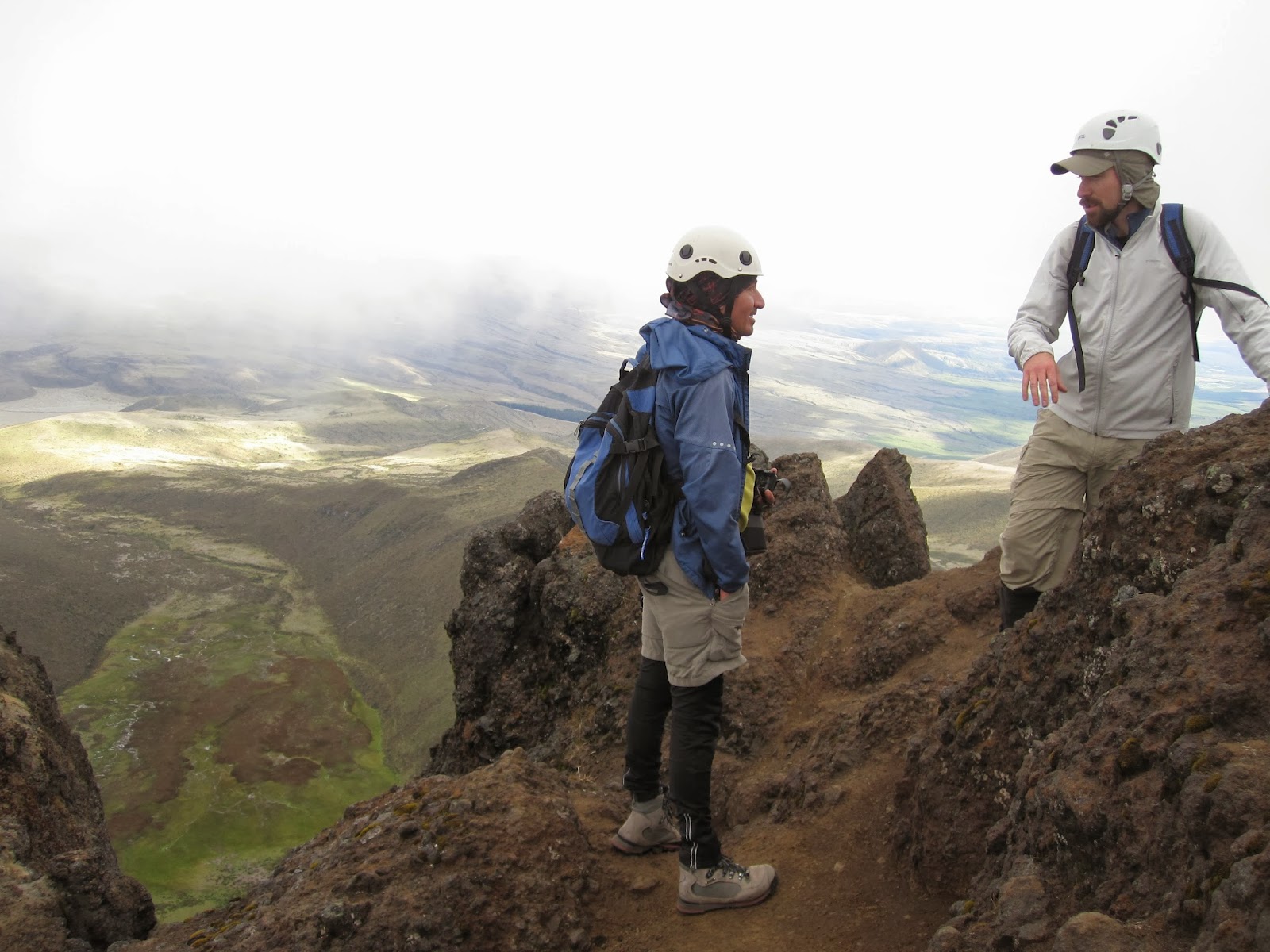 |
| Discussing how fun it is to climb up mountains. |
 |
| Ruminahui with the sun setting behind. |
We watched the sun set behind the rugged mountain and one of my top five favorite ridges and felt happy. Sometimes turning around is important when in nature. When we did we saw a rainbow lighting up the sky in front of Cotopaxi.
 |
| I recommend visiting Cotopaxi National Park. |
We trudged back down the road to the hostel for dinner, happy as can be and trying to put to words our enjoyment. While on the hike we had sandwiches built from the materials Juan Carlos had wisely chosen at the market. When we returned to the lodge, he cooked an entire chicken and gave us some protein for the next day.
 |
| Forgive me for the instagram-type photo. It tasted so good though. |
The next day was glacier training. This day was a bit dreary so not too many photos. We headed up to the refugio to strap on the crampons and find a small glacier. Self-arrest is an important skill on Cotopaxi. Thankfully the Intro to Mountaineering course in Fairbanks provided basic skills to work from. After an afternoon up we headed back to eat a lot and rest for the big climb the next night.
 |
| One person runs downhill, the other gets yanked off their feet and tries to stop sliding. Mind the crevasse. Photo by Brooks. |
The next day at the hostel started out dreary as well. But to our surprise, as we headed up towards Cotopaxi the skies cleared.
 |
| Cotopaxi flanked by clouds. |
 |
| Herd of horses and Cotopaxi. Photo by Brooks. |
 |
| The Jose Ribas Refugio parking lot. |
As you can tell from our driver's face in the photo above, the wind was howling. After we settled in, I took a walk around, looking to take some pictures. By this time, clouds were again closing in on the summit above.
 |
| Cotopaxi glaciers above the refugio. |
 |
| Jose Ribas Refugio. Pretty sturdy structure. |
The clouds were behaving strangely. They were moving towards each other from the east and west. We were watching the collision of two air masses, one from the Pacific Ocean, the other from the Amazon rainforest. And for some reason where they met there were clear skies and it was extraordinarily windy. I don't know how that works but next time I talk to a meteorologist I will bring it up.
 |
| Pacific moisture from the left, Amazonian moisture from the right. |
Inside the refugio was very pleasant, especially because of the wonderful meal prepared by Juan Carlos and endless horchata tea. I had heard that good hydration is important when at high altitude in cold temperatures. Horchata and brown sugar is a very good way to get hydrated.
 |
| Preparing in the refugio. |
There were two other parties in the refugio who were planning to climb. One group had tried to go from sea level to the refugio without acclimatization and they looked like death. The other group had no guide and they nervously asked Juan Carlos about the recent route changes caused by a crevasse opening up a little to wide. I was glad we didn't have to try to learn the route. Thankfully all we had to do is get roped up and follow the leader.
After our meal it was time to sleep. Cotopaxi climbs start at midnight so we hopped in sleeping bags and tried to sleep. This was difficult for two reasons; 1) I was really excited and 2) the wind was still howling and didn't sound as though it was letting up. I don't think Brooks and I ever asked if the wind would keep us from trying for the summit, but my Midwest brain said that we shouldn't climb a mountain in this type of weather. So I laid there and listened to the wind and tried to make peace with the possibility of not being able to climb.
Then 11:30 came and Juan Carlos told us to suit up. Not even a bit of hesitation or worry about the wind. Deal. Let's get after it. We were out the door by 12:05.
The climbing was wonderful. Crampons, ice axes, headlamps, and blowing snow for about 5 hours. At one point we had to drop down into a crevasse as another crevasse further up on the main route had widened far enough it couldn't be jumped. Occasionally our headlamps would light up a feature that helped us understand our location and the importance of self-arrest. Right after the crevasse adventure we crossed above a large sloped snow field. Good stuff. Juan Carlos kept providing updates. 800 meters left, 500 meters, last break at 200 meters. Suddenly we were there. And we couldn't see anything because we beat the sun. Also we were getting whipped in the face with blowing snow.
 |
| Top of the world Ma! Woo! Photo by Juan Carlos. |
 |
| Summit selfie. Photo by Juan Carlos. |
Everything had gone perfectly. Our guide knew the mountain well enough that he could confidently say "go" in conditions that weren't ideal.
We lingered on the summit for a few moments and then, WHAM! The clouds on the summit started to pull apart and we got our first few looks at spectacular. I realized I was looking north towards Volcan Antizana and it was very big and we were very high. The early morning glow put colors in the sky like I've never seen. I'd like to think that we had a brief look into the caldera but I think I made that up in my mind. No photos as the breaks in the clouds lasted less than 2-3 seconds. Probably a good thing. We started down, feeling pretty good. Feeling deliriously happy maybe.
As we dropped off the summit the clouds really parted. Brooks grabbed a picture of the shadow of the thing we were on.
 |
| Cotopaxi's shadow on the clouds. Photo by Brooks. |
The route brought us back to the north side of Cotopaxi and Cayambe and Antisana appeared around the corner.
 |
| An extraordinary slope with Volcan Cayambe on the left and Antisana on the right. |
 |
| Getting ready to head into the maw in daylight. Photo by Brooks. |
 |
| The maw of the glacier and Volcan Antisana above the clouds. |
 |
| The Ilinizas to the west. Those are on the list. |
 |
| Cayambe and Antisana again. |
 |
| The Ilinizas above the clouds. Photo by Brooks. |
 |
| Ruminahui's dark ridge above the clouds. Photo by Brooks. |
Before long we were back at the refugio looking up at the summit against bluer than blue skies. Again I was glad to have a guide as snow conditions changed rapidly. The crust from the night before turned into a foot of slush ready for a wet slab avalanche. We hopped off the snow and out of avalanche danger around 8.
 |
| Cotopaxi's prominent cliff and hanging glacier. |
The west wind and east wind were still battling it out in the valley below.
 |
| Blue skies on the boundary. |
 |
| Heading down from the refugio. |
 |
| Antisana in the sun. |
 |
| The refugio and Cotopaxi. |
 |
| Getting ready to head back to Quito. |
Tremendous trip. Of course I want to go back and bring friends. There are several volcanoes down there. All the ones we visited had their own beauty. Juan Carlos Bastidas is a great guide and a better cook. He was patient and seemed to be enjoying himself despite the gringos, and despite he had walked up Cotopaxi the morning we met him. When I googled his name before we headed down to Ecuador, I found a website that described being guided by Juan Carlos as climbing with a friend rather than a guide. I agree. It is fun to hang out with someone who enjoys sharing the experience of climbing with other people as much as he does.
I think it is good to climb up and soak in views. Part of the reason those experiences exist is because sometimes here and now looks a little bit like eternity. Jesus often asked the people he was speaking with to imagine eternity, to take what they see and project it forward to create a picture of what eternity is like. God used mountains and clouds to communicate to me how much I will be amazed by him, among other things. Probably better than if I had read it in a book. The Bible shouts God's greatness and demands awe. The right response to the cross is awe and worship but it is hard to produce those emotions thinking about something that happened two thousand years ago that I didn't see. It takes an imagination that I sometimes don't have. But every mountain says of the wonderful cross, "It's true! It's true! It's true! And it's like THIS!!!!"
For now we see in a mirror dimly, but then face to face. Now I know in part; then I shall know fully, even as I have been fully known.
(1 Corinthians 13:12 ESV)
I am looking forward to having unveiled eyes. I want to go from interpretation to experience. I want to say, "The reason I had so much fun on top of mountains in Ecuador is because it looked and felt a little bit like understanding all the meaning and all the weight of the cross!"
Brooks and I don't speak a ton of Espanol but our driver could still communicate with us pretty well.
 |
| Couldn't agree more. |

